
Links and Resources
ICESat's Mission
Are the ice sheets that still blanket the Earth's poles growing or shrinking? Will global sea level rise or fall? NASA's Earth Science Enterprise (ESE) has developed the ICESat mission to provide answers to these and other questions to help fulfill NASA's mission to understand and protect our home planet. The primary goal of ICESat is to quantify ice sheet mass balance and understand how changes in the Earth's atmosphere and climate affect the polar ice masses and global sea level. ICESat will also measure global distributions of clouds and aerosols for studies of their effects on atmospheric processes and global change, as well as land topography, sea ice, and vegetation cover.
Ice sheets are complex and dynamic elements of our climate system. Their evolution has strongly influenced sea level in the past and currently influences the global sea level rise that threatens our coasts. Ice streams that speed up, slow down, and change course illustrate their dynamic nature. Atmospheric factors cause snowfall to vary in space and time across their surfaces.
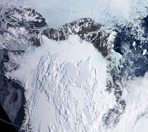
In Antarctica, small ice shelves continue to retreat along the Antarctic Peninsula, and large icebergs are released from the largest ice shelves. In Greenland, the ice sheet margins are thinning and the inland parts of the ice sheet appear to be thickening. Surface meltwater seeps into the ice sheets and accelerates their flow. Some of the factors controlling the mass balance of the ice sheets, and their present and future influences on sea level, are just beginning to be understood.
The ICESat mission, part of NASA's Earth Observing System (EOS), is scheduled to launch in December 2002. GLAS on ICESat will measure ice sheet elevations, changes in elevation through time, height profiles of clouds and aerosols, land elevations and vegetation cover, and approximate sea ice thickness.

Future ICESat missions will extend and improve assessments from the first mission, as well as monitor ongoing changes. Together with other aspects of NASA's ESE and current and planned EOS satellites, ICESat will enable scientists to study the Earth's climate and, ultimately, predict how ice sheets and sea level will respond to future climate change.
For more information about ICESAT and GLAS please view the ICESat Brochure (2 MB, .pdf file)